Philtra l Salomon Community Run - Baguio
October 06, 2024

Categories
Free Community Run
Volunteer
Registration Ended
1 year ago
The Community Run aims to bring anyone and everyone to a trail experience to remember. The good news is it is FREE. Happening at Camp John Hay in Baguio City, join us this October 6 at 6am.
Experience off road running, hike and walk through the scenic beginner trail in Camp John Hay. Challenge yourself to run uphill and downhill safely with your pace group. Take pics, smile and have fun. Refreshment awaits at the finish line.
Choose your distance:
- 5K Trail Run (290 elevation gain)
- 10K Trail Challenge (570m elevation gain)
Participant must pre-register to join. Please arrive at least one hour before the gun start and show your registration and a valid ID at ROX in Baguio City. All participants must have a timing bracelet.
Lead runners will be around to help everyone navigate the trails. GPX will be available and it is mandatory for participants to download this on their phone or watch. We will be posting information on how to use a GPX file and will have training onsite before the event (Please wait for details.).
Participants must bring at least 250ml water for 5k and shorter or 500ml for 10k and their favourite snack (trail food). Everyone must have a whistle.
Note: Participants are responsible in ensuring they are physically fit for the activity.
Event Schedule
Please arrive early to allow time for check-in and warm-up.
- Volunteer Call-time: 4am
- Start of Check-in: 530am
- Start of Opening and Warm-up: 6:30am
- Take-off: 7am
Raffle, socials and games starts at 9am
How to check-in
⁃ Present your ID
⁃ Get your bracelet
⁃ Check-in at the waiting area of the distance you’re running - 5k and 10k
Release will be by pace group and we will have lead runners and pacers.
EVENT MECHANICS
This is an easy, beginner friendly community event! However, we wish to remind the following basics when you go out on the trails.
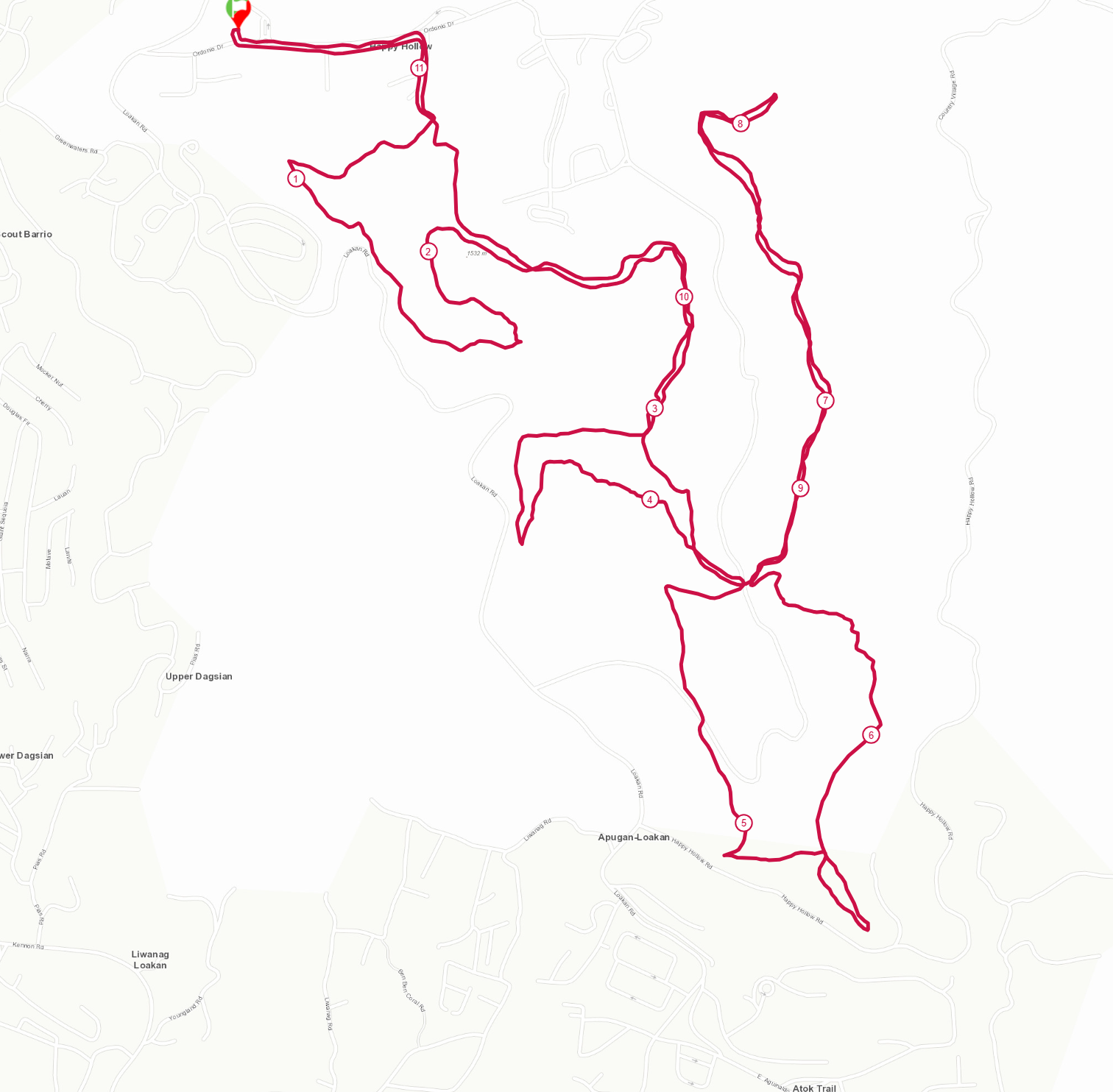
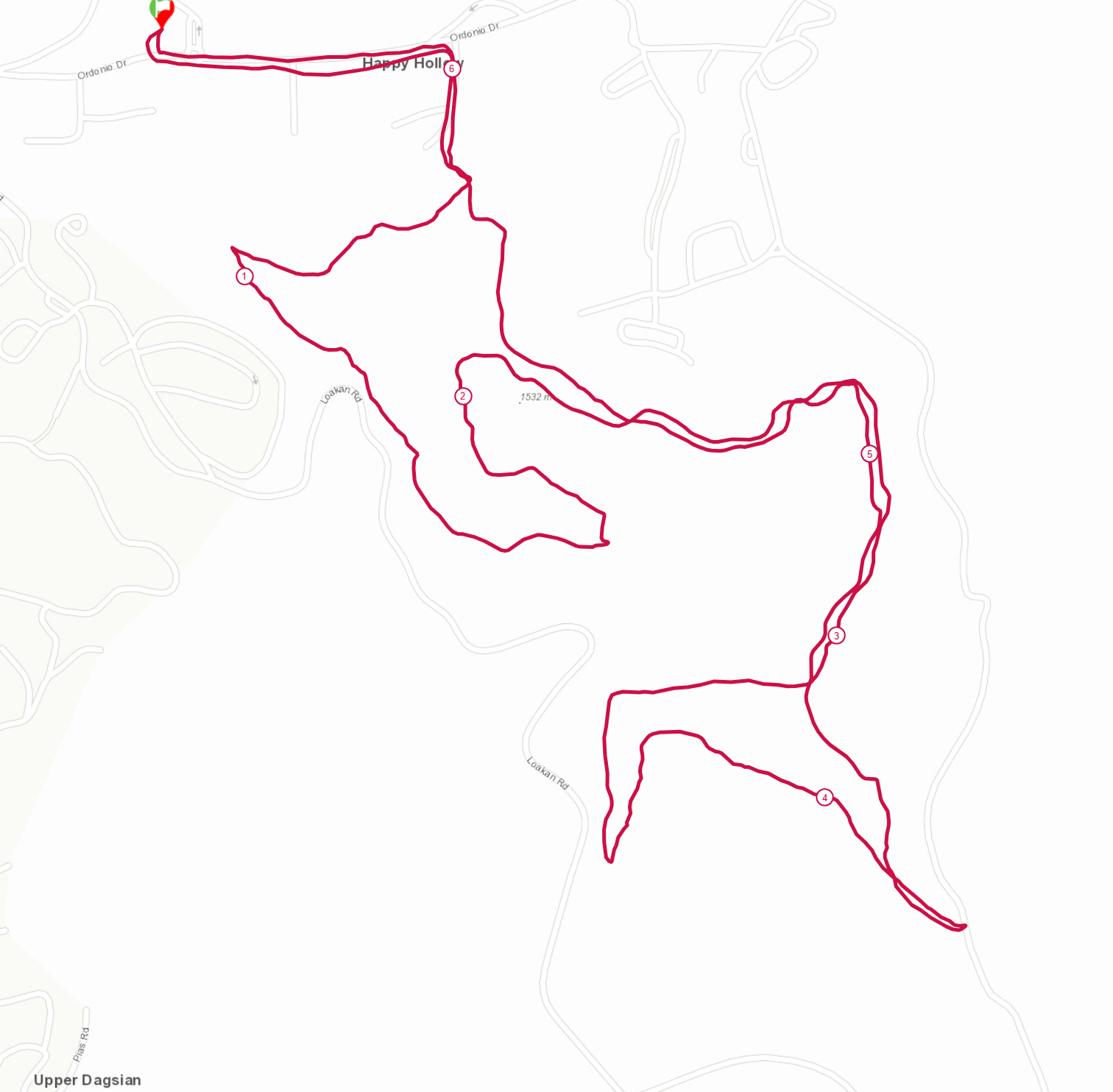
1. Plan Your Route: Know the trail, its length, and difficulty. Check the map above. The route shows the difficulty level of the trail. Please ensure that you are physically prepared for it. We will have lead runners and pacers, marshals and medics on the route. The course will be marked and there will be signages installed. Please stay on course.
2. Check the Weather: Dress appropriately and be prepared for changes.
3. Stay Hydrated: Bring enough water and maybe an electrolyte drink or light snacks. It will be mandatory for this event to bring a 250ml water (can be in a bottle or a pack) for 5K and a 500Ml for 10k.
4. Wear Proper Gear: Trail running shoes, moisture-wicking clothing, and a hat or visor and a rain jacket depends on the weather.
5. Pack Essentials: First aid kit, map, phone, and a small snack. A WHISTLE is mandatory so you can use this as signal if needed.
6. Run Smart: Start slow, watch your footing, and be aware of wildlife. This is a COMMUNITY RUN so we will go together. Enjoy it, take photos, pace with other members, speed up with caution if you feel like it but be aware of the markings and the signages so you won't get lost.
7. Leave No Trace: Respect nature, stick to the trails, and carry out all trash.
8. Check in and check out at the start. Participants will all be issued a Timing Bracelet. This will ensure that we are able to track you as you leave the starting point and comes back to the finishing point. Kindly report back to the marshal and your lead runner if you plan to stop. We always ensure everyone is back safely and happy. :) Participants who will be accounted as did not finish but did not report will be traced and may trigger rescue and search operation so it is important that we are able to account for everyone.
Happy trails!
NAVIGATING THE TRAILS USING THE GPX OF THE ROUTE
The Course:
To help you navigate the course, we’ve made the GPX file for your race available. Download it[GPX download link- https://drive.google.com/drive/folders/1-jtpoGhLX6CXQTSocogOY9JzclRWqFDM], and make sure to load it on your GPS device or app before race day.
The course will be marked partly but we hope that through this eventyou’ll be equipped with use of the gpx file which is a handy tool and an important skill for trail runners.
How to use a GPX file when navigating the trails:
To use a GPX file on your phone for navigation, you'll need a GPS or mapping app that supports GPX files. Here's a step-by-step guide for some popular apps:
1. Using GPX with Strava (iOS/Android):
- Step 1:Download the GPX file to your phone (it may save to your downloads folder or files app).
- Step 2:Open the Strava*] app and go to the Dashboardor **Explore** tab.
- Step 3: Tap on Routes and then on the "+" icon to create a new route.
- Step 4: Select Import and choose the GPX file from your phone.
- Step 5: Once imported, you can save the route and follow it during your run. Strava will show you the path on the map, and your live location as you move.
2. Using GPX with Komoot (iOS/Android):**
- Step 1: Download the GPX file to your phone.
- Step 2: Open the **Komoot** app, and navigate to the **Profile** tab.
- Step 3:Tap **Planned Tours** and select **Import GPX File**.
- Step 4: Find the GPX file you downloaded and import it.
- Step 5: Once imported, Komoot will plot the route on a map. You can follow the route while tracking your position in real-time.
3. Using GPX with Gaia GPS (iOS/Android):**
- Step 1:Download the GPX file to your phone.
- Step 2:Open the Gaia GPS app, and tap on the Menu icon (usually three horizontal lines).
- Step 3: Tap Import File and choose the GPX file from your device.
- Step 4: Once imported, the route will be shown on the map. Use the app's navigation features to follow the GPX route during your run.
4. Using GPX with AllTrails (iOS/Android):
- Step 1: Download the GPX file to your phone.
- Step 2: Open the AllTrailsapp.
- Step 3: Tap Plan and then select Import a Route.
- Step 4: Choose the GPX file from your phone.
- Step 5: AllTrails will load the route on the map, allowing you to follow it and see your location in real-time.
5. Using Google Maps (with conversion) (iOS/Android):
Google Maps doesn’t natively support GPX files, but you can use third-party apps to convert GPX to KML format.
- Step 1: Use an online tool like GPS Visualizer to convert the GPX file to a KML format.
- Step 2: Go to Google My Maps (accessible via the web browser) and import the KML file.
- Step 3: Once imported, you can open the custom map with Google Maps on your phone and use it to navigate.
6. Using GPX Viewer (iOS/Android):
- Step 1: Download the GPX file to your phone.
- Step 2: Install and open the GPX Viewer app.
- Step 3: Tap the folder icon to open the GPX file from your device.
- Step 4: The app will display the route, and you can track your location on the map as you move.
General Tips for Using GPX Files on Your Phone:
- Ensure GPS is enabled: Make sure your phone’s location services are turned on to accurately track your position.
- Download the map offline:If you're running in areas without cell service, download the map for offline use in the app (most apps have this feature).
- Test the route before the event: Open the GPX file and follow the route for a short distance to ensure it's working properly.
Download GPX file: CLICK here -
MAP (Subject to Change)
10K MAP (Actual Distance 11.5k)
Click the photo to view the interactive map and elevation gain details. You may also download the gpx HERE
5.5K Map (Actual 6.5K)
Click the photo to view the interactive map and elevation gain details. You may also download the gpx HERE
Book a Room at 30% Off at Podium Botique Hotel
Show your proof of registration and get 30% off your booking for this weekend. Click photo to visit their website.
Option 1 (Bus via Genesis Transport & Victory Liner, Cubao)
- Ride the LRT 2 or MRT 3 train and choose ‘Araneta Center Cubao’ terminal station as your drop off point.
- From there, you can choose from any of these modes of travel in heading to the bus terminal stations.
- Ride a jeepney and state ‘Baliwag’ station as your drop-off point. From there, you can either take a 3-minute walk to Victory Liner station or a 5-minute walk to Genesis Transport station.
- Take a 10-minute walk to Victory Liner station or a 15-minute walk to Genesis Transport station.
- If you choose to travel via Genesis Transport, you can ride on their subsidiary bus line named JoyBus. And if you choose to be on Victory Liner’s bus, you can easily proceed right away.
- Submit your purchased ticket, take a seat, and enjoy the ride on your way to Baguio.
Option 2 (Bus via Genesis Transport & Victory Liner, Pasay)
- Ride the LRT 1 train and choose ‘Baclaran’ terminal station as your drop off point.
- From there, you can either:
- Take a 13-minute walk and head towards Victory Liner Pasay terminal; or
- Take a 3-minute walk and head towards Genesis Transport Pasay terminal. You can ride on their subsidiary bus line named JoyBus.
- Submit your bus ticket to Baguio and you’re good to go.
Via jeepney: You can take the Scout Barrio jeepney and ask to be dropped off at Camp John Hay. Regular jeepney fare costs Php10.00. PUJs do not enter Camp John Hay so you will only be dropped off at the Gate 1 entrance. Follow the map to ROX
